
From tonight, a significant deterioration in the weather is expected, with thunderstorms, snowfall and hurricane winds in island, foothill and mountainous regions.
Yesterday, the National Weather Service released an emergency weather hazard bulletin that has been updated today.
According to his predictions National Observatory of Athensa barometric low in the Central Mediterranean will cause a multi-day wave of bad weather in Greece, which will last until the weekend.
Problems are already fixed in Zakynthos and Imathia, and in the coming hours the phenomena will intensify. in Epirus, Western and Northern Thessaly and Western Macedonia, according to meteo.gr.
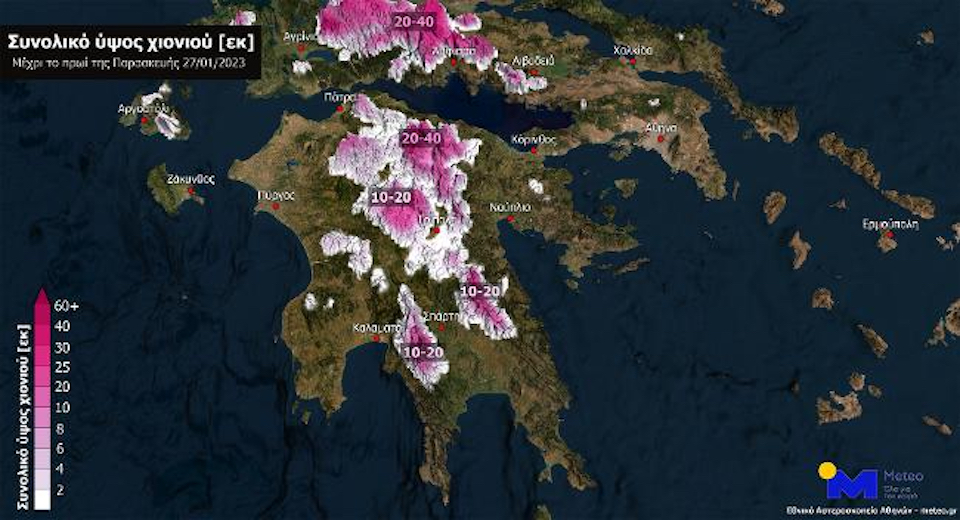
At what height will it snow?
Pifrequent snowfalls they will hit, locally, in the highlands of the mainland, at an altitude of more than 900 meters in the north and above 1300 meters in other areas that will be swept up by bad weather.
In the middle of the night, snow will fall on you too semi-mountainous regions of central and northern Greece with a height of more than 600 meters.
Activation 112
Against the background of forecasts of extreme weather events, a wide-ranging meeting was held today with the participation of the political leadership of the Ministry of Climate Crises and Civil Protection, the fire department, meteorologists, hydrologists and co-competent departments.
The competent authorities decided to activate the 112 system to send warning messages to residents of specific areas, depending on the development of phenomena.
AT Imathia, heavy rains caused the pavement to cave in, causing part of the Paleo Prodromos-Coulouras bridge to collapse, ERT reported.
closed schools
Tomorrow, misterall schools in Zakynthos, Ithaca and Kefalonia will remain closed by his decision Deputy Governor Stavros Travlos. A similar decision was made by the municipality of Argos-Mycenae.
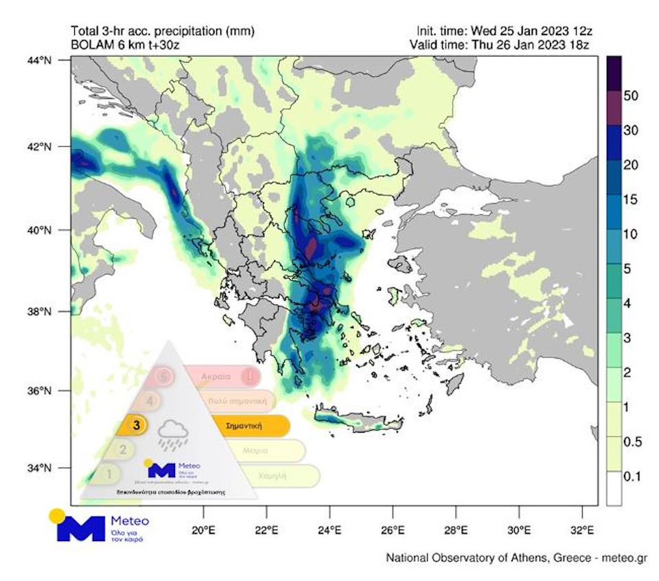
Heavy rain and snow on Thursday – precipitation category 3
The National Observatory of Athens warns that tomorrow, first in the Ionian Islands and in the west of the mainland, there will be heavy rains and storms, which will be locally accompanied by increased electrical activity and hail.
The rest of the country will experience local precipitation.
powerful phenomena they will gradually move further east and will affect the whole country. The areas that will be affected include both the prefecture of Attica and its city. Athens, as well as its prefecture and city Thessaloniki.
There will be fewer events in Crete and until late in the evening in Thrace. According to the classification of precipitation episodes (RPI) used by the Meteorological Service of the National Observatory of Athens, the precipitation episode is classified as Category 3.
The forecast map below shows the expected distribution of rain over a three-hour period from 17:00 to 20:00 on Thursday.
Fire brigade spokesman Ioannis Artopios explained that this phenomenon has been ongoing since last Thursday, consistently affecting our country. More intense phenomena still appear in the Pell regional unit. on Monday when the PS Operations Center received 115 calls to pump out water in the wider area of Aridia and action was taken on 36 occasions.
Heavy rain and thunderstorms are expected from today through Friday, accompanied by strong winds and snowfall. “The phenomenon will first manifest itself in the west, in the center and in the south and will gradually spread to the northeast of the country,” he said.
Recommendations to citizens
OUR The General Secretariat for Civil Protection issues an urgent recommendation to citizens be very careful.
“We recommend limiting movement to those that are absolutely necessary,” a spokesman for the fire department said, saying a broad coordination meeting would be held tomorrow to reassess the course of the storm.
Instructions from GPP
With recommendations to citizens to be especially careful, taking care of taking self-protection measures against the risks arising from the manifestation of severe weather events, the General Secretariat of Civil Protection addresses in connection with the upcoming bad weather.
In particular, in areas where heavy rainfall, thunderstorms, or gale-force winds are forecast, the Public Health Service recommends that citizens:
- To secure objects that, if blown away by severe weather conditions, could cause damage or injury.
- Make sure the gutters and downspouts of the houses are clear and working properly.
- Avoid crossing streams and streams on foot or by car during storms and rains, and for several hours after they end.
- Avoid working outdoors and operating in sea and coastal areas during adverse weather conditions (danger of lightning strikes).
- Take cover immediately during hail. Take shelter in a building or car and do not leave the safe area until they are sure the storm has passed. Hail can be very dangerous for animals too.
- Avoid walking under large trees, under posted signs, and in public areas where light objects (eg pots, broken glass, etc.) can break off and fall to the ground (eg under balconies).
- Conscientiously follow the instructions of local authorities such as the Road Traffic Authority, etc.
- Be aware of the weather and the state of the road network
- Have snow chains on your vehicle and a full tank of fuel.
- Travel as needed, preferably during the day, preferring major roads.
- To inform your relatives about the route they are going to take
- Change your travel schedule to avoid peak weather.
- Conscientiously follow the instructions of local authorities such as the Road Traffic Authority, etc.
- Dress in several layers of light clothing rather than heavy clothing and wear suitable footwear to avoid slippery injuries.
- To avoid unnecessary movements during the peak of phenomena (heavy snowfall, frost)
Source: Kathimerini
Ashley Bailey is a talented author and journalist known for her writing on trending topics. Currently working at 247 news reel, she brings readers fresh perspectives on current issues. With her well-researched and thought-provoking articles, she captures the zeitgeist and stays ahead of the latest trends. Ashley’s writing is a must-read for anyone interested in staying up-to-date with the latest developments.