
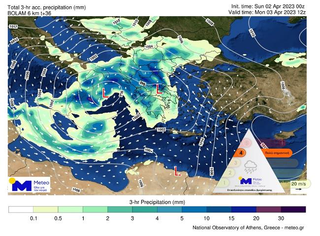
In progress bad weather “OR AT” which is expected to affect the country today and tomorrow with heavy rains and storms accompanied in places by a high frequency of lightning, hail and strong winds.
According to the EMY emergency bulletin, as of today they are scheduled heavy rains and storms:
- from the morning hours in the Ionian Sea
- from noon in Epirus, western Macedonia, western Sterea, western and southern Peloponnese
- from noon in Thessaly, central Macedonia and central Sterea
- from noon in eastern Macedonia and gradually to evening hours in Thrace, on the islands of the northern and eastern Aegean and the Dodecanese.
The phenomena in the Ionian Sea, Epirus, western Macedonia, western Sterea, western Peloponnese, Thessaly and central Sterea will weaken in the evening hours.
Strong south-southeast wind intensity from 7 to 8 Beaufortwill prevail in the eastern Aegean from today until early Tuesday morning.
Monday weather from Meteo
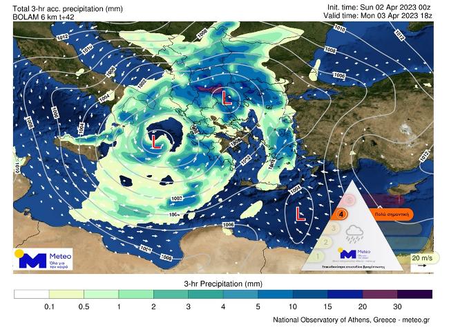
Bad weather with intense phenomena is expected today almost throughout the country. Until noon, the phenomena will be located in the Ionian, continental bodies (with the exception of Eastern Macedonia and Thrace) and the western parts of the Aegean Sea.
Starting from noon, the effects will gradually spread to East Macedonia and Thrace, and the front of severe storms will cross the Aegean Sea from west to east.
Snowfall, heavy in places, will occur in the continental highlands with estimated elevations of over 1800m in the south, over 1500m in the rest and over 1000m in the northwest.
At the same time, the concentration of dust in the atmosphere will increase, which will cause mud rains.
OUR temperature there will be a slight decrease and will fluctuate in Northern Greece from 3 to 18 degrees, in Thessaly and Epirus from 9 to 16 degrees, in the rest of the mainland from 11 to 17-19 degrees, in the Ionian Islands from 12 to 16 degrees. , on the islands of the Aegean Sea and on Crete from 13 to 21-22, and in Crete the maximum will reach 24 degrees Celsius.
winds in the northern part of the Aegean, they will blow from easterly directions with a force of 5-6, and in some places with a force of 7 on the Beaufort scale, while in the rest of the Aegean, south-south-easterly winds of force 6-7 will prevail, and places at 8 points on the Beaufort scale. Southerly winds up to 6 on the Beaufort scale will blow in the Ionian Sea.
IN Attica expect cloudy with rain or thunderstorms mostly during lunch and evening hours. The wind will blow from the south with a force of 4-5, in places 6 on the Beaufort scale. The temperature will fluctuate from 13 to 17-18 degrees.
IN Thessaloniki we expect rain and progressing storms. The effects will be strong in places and at times. The wind will blow from the east with a force of 4-5, in places 6 on the Beaufort scale, but in the afternoon it will weaken and change to the south. The air temperature will fluctuate from 8 to 14 degrees.
News today
Subscribe to kathimerini.gr on Google News and be the first to know all the news
See all the latest news from Greece and the world at kathimerini.gr
Source: Kathimerini
Ashley Bailey is a talented author and journalist known for her writing on trending topics. Currently working at 247 news reel, she brings readers fresh perspectives on current issues. With her well-researched and thought-provoking articles, she captures the zeitgeist and stays ahead of the latest trends. Ashley’s writing is a must-read for anyone interested in staying up-to-date with the latest developments.