
Imagine a beam invisible to the human eye. lasera few centimeters in diameter, which is ejected into the atmosphere and in a few billionths of a second “illuminates” suspended bioparticles as if they were fireflies. They then fluoresce and thus “witness” their presence. Here’s How It Works laser remote sensing system (lidar technology) developed at the Laboratory of Optoelectronics and Lasers of the National Technical University of Athens.
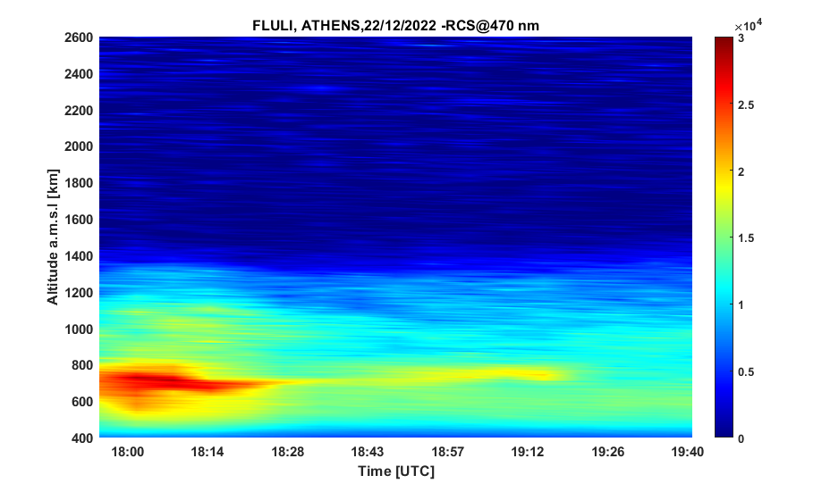
The same method was used during the holidays to record concentrations of particulate matter from biomass combustion in fireplaces and central heating in the Athens Basin, which were two and three times the European Union legal limit.
Global innovation
A lidar technology system entirely built and developed in-house Applied Mathematics and Science NTUA is a world leader because it is the only one that provides information by combining three different parameters (time, space and species/chemical composition of particles) and three different sciences (physics, chemistry, mathematics). Such data on the atmosphere can only be obtained with the help of measurements taken from aircraft – obviously at a much greater cost.
The purpose of the system is to monitor the spatiotemporal change in the vertical distribution of not only bioparticles (bacteria, fungi or pollen), but also various types of particles (desert dust, volcanic ash, smoke) in the lower atmosphere.
The man who brought this technology to Greece and is the director of the NTUA Laboratory of Optoelectronics and Lasers, Alexander Papagiannis, describes it as a “real-time 3D map computed tomography”. In fact, measurements are made every 7.5 meters, and the total range of the system reaches 20,000 kilometers.
In general, as he explains, the system works as follows: laser ray in the atmosphere, where, interacting with various particles and molecules, returns one signal. Because the speed of light is known, NTUA scientists can calculate it. distance where does this information come from.
Thanks to the fluorescence method, extremely small particles with a size of several micrometers or even nanometers are recorded. Through fluorescence, each individual particle responds to its own spectrum, leaves its signature, so to speak, and reveals its own particular identity.
From pollution to aviation and nuclear accidents
Thus, the lidar method is useful for its registration. air pollution which is dangerous for both the environment and humans. The study of bioparticles and Effect in the human body – a research area studied by the Laboratory of Optoelectronics and Lasers since 2019, innovative again globally.
Mr. Papagiannis points out the serious health consequences of burning biomass particles and derivatives. The main one is DNA damage from oxidation which in turn leads to inflammation of the airways and possibly to cellular mutations leading to carcinogenesis.
The application of this technique is multifaceted. “The whole idea is to analyze information coming to us from different distances. Lidar technology makes it possible to record the vertical distribution of various atmospheric parameters, such as temperature, humidity, concentration of suspended particles and ozone“, notes Mr. Papagiannis.
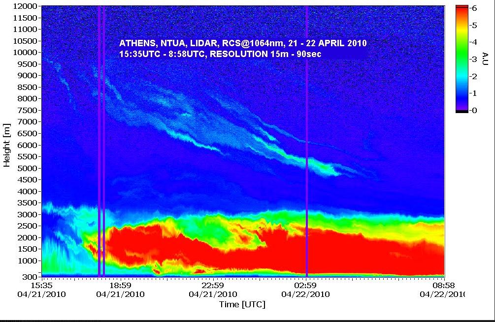
The Laboratory of Optoelectronics and Lasers belongs to the founding members of the European Lidar Network (its name is Earlinet), which has been recording the concentration of suspended particles on the Old Continent for 23 years. In this way, as the NTUA professor explains, pan-European data on atmospheric quality are recorded, such as desert dust transport phenomenon (for example, from the Sahara, Kazakhstan, even from the Arabian Peninsula) or ash particles from volcanic eruptions (as was the case in Iceland in 2010 and more often with our neighbor Etna).
In cases like the latter, lidar can help. air navigation And political defense. “Instead of closing all airspace and all flights in Europe, as was done in 2010, it is possible to choose the heights at which aircraft can fly, thanks to the available data on the existence of layers of ash particles and their direction in real time. time”.
Another possible use in nuclear or industrial accident. If this happens, a dedicated remote sensing system “could provide real-time measurements of airborne particles. If such a wave comes either with nuclear particles or with chemical compounds from the plant, we can take action, as we will see how high it is, how quickly it falls to the ground and where it goes.”
The next target is the clouds
Finally, it is obvious that the lidar method is also useful in meteorology, but also in world climate study. “If we know what the vertical distribution of particles is and what their chemical composition is every 7.5 meters up to 20,000 kilometers, we can calculate particulate matter in the climate,” notes the director of the NTUA Laboratory of Optoelectronics and Lasers.
For this reason, Mr. Papagiannis will be next semester at the Federal Polytechnic School of Lausanne as a visiting professor, where in a joint study the effect of bioparticles on creating clouds.
“We will see what particles and how they are involved in the creation of clouds, as well as Kind created clouds (rain, pollution, dust causing overheating),” he concludes.
*Measurements of bioparticles were carried out within the PANACEA/PANAKEIA National Infrastructure.
Source: Kathimerini
Ashley Bailey is a talented author and journalist known for her writing on trending topics. Currently working at 247 news reel, she brings readers fresh perspectives on current issues. With her well-researched and thought-provoking articles, she captures the zeitgeist and stays ahead of the latest trends. Ashley’s writing is a must-read for anyone interested in staying up-to-date with the latest developments.