
On Friday, meteorologists issued a weather advisory for moderate snow and increasing winds for much of the country, as well as a code yellow warning for significant snow and blizzards in the mountains for 26 counties, both in effect until Sunday. The weather will get colder from Sunday
According to the ANM, from 10:00 a.m. on February 3 to 6:00 p.m. on February 5, the area of snow will gradually expand in the evening from the northwestern regions and cover most of the country. A new layer of snow will fall locally, which will be more stable in mountainous areas. Due to the accumulation, the amount of water in some places will exceed 20-30 l/m2, especially in the western half of the country.
Local temporary strengthening of the wind, average speeds in most areas of 50-60 km/h, gusts of 65-75 km/h in the mountains. There will be periods when increased wind will be accompanied by snow.
The weather will get colder from Sunday
“From Sunday (February 5), the weather will enter the process of cooling and will become frosty at night, especially in the Carpathian region,” meteorologists say, talking about a wave of polar air that will envelop our country.
- “This very cold air mass will be best felt on Saturday night and then on Sunday, Monday and Tuesday when temperatures will gradually and sharply drop.
- In the western half of the territory, especially in the remaining smaller areas, it will be frosty at night.
- On Friday and even Saturday, we are talking about pleasant temperatures for this period, maximum temperatures that will still reach values of 7-8 degrees in the southern part of the territory.
- Saturday will also be good in the southern half, also with values of 7-8 degrees, but from Saturday to Sunday it will be much colder in the Inner Carpathian regions, where this time the minimum temperatures will reach the zero mark. , i.e. values of -10 degrees and will even fall below them, and in the rest of the territory they will be slightly negative. Sunday, Monday, I said, during the day the temperature will be very low.
- The maximum air temperature will be below zero almost throughout the country, in the lowlands – from -7 to 6 degrees of frost, in the south of the territory and at night from Saturday to 0-2 degrees of heat. On Sunday, Sunday closer to Monday and Monday closer to Tuesday, most of the country will experience frosts,” Alina Sherban, ANM meteorologist, told CNN’s Antena 3.
Also, from 8:00 p.m. on February 3 to 6:00 p.m. on February 5, there will be short-term snow, in some places the wind will increase with gusts of 50-70 km/h, and the wind will increase at an altitude of more than 1,800 meters. will exceed 80-90 km/h, so there will be blizzard and low visibility.
In the west of the Southern Carpathians, more than 30-40 l/m2 will accumulate, a significant layer of snow will fall.
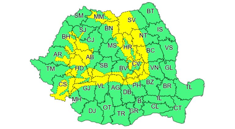
Counties covered by the yellow snow code: Alba, Arges, Arad, Bacau, Bihor, Bistrita-Neseud, Brasov, Buzau, Cluj, Caras-Severin, Covasna, Dambovitsa, Gorges, Hunedoara, Harghita, Mehedinci, Maramures, Mures, Neamc , Prahova, Sibiu, Selay, Suceava, Timis, Vilca and Vranca.
What will the weather be like in Bucharest?
The sky will be temporarily covered with clouds and from the evening of Friday (February 3) there will be light precipitation, snow at night, and on Saturday (February 4) also in the form of rain.
The wind is weak and moderate, it will increase somewhat on Sunday, when the speed will be 40…45 km/h in general.
The maximum temperature will drop significantly, from 8…9 degrees on Friday to about 1 degree on Sunday, the minimum will be -2…0 degrees. (Sources Agerpres, news.ro)
Source: Hot News
Ashley Bailey is a talented author and journalist known for her writing on trending topics. Currently working at 247 news reel, she brings readers fresh perspectives on current issues. With her well-researched and thought-provoking articles, she captures the zeitgeist and stays ahead of the latest trends. Ashley’s writing is a must-read for anyone interested in staying up-to-date with the latest developments.