
An atmospheric disturbance from the wider Adriatic region (Northern Italy – Western Balkans) is expected to cause a significant change weather in the new week, according to the latest forecast data from the National Observatory of Athens / meteo.gr.
The main signs of this change will be precipitation and thunderstorms, which will be intense in places and will be accompanied by hail, very strong gusty winds and intense electrical activity.
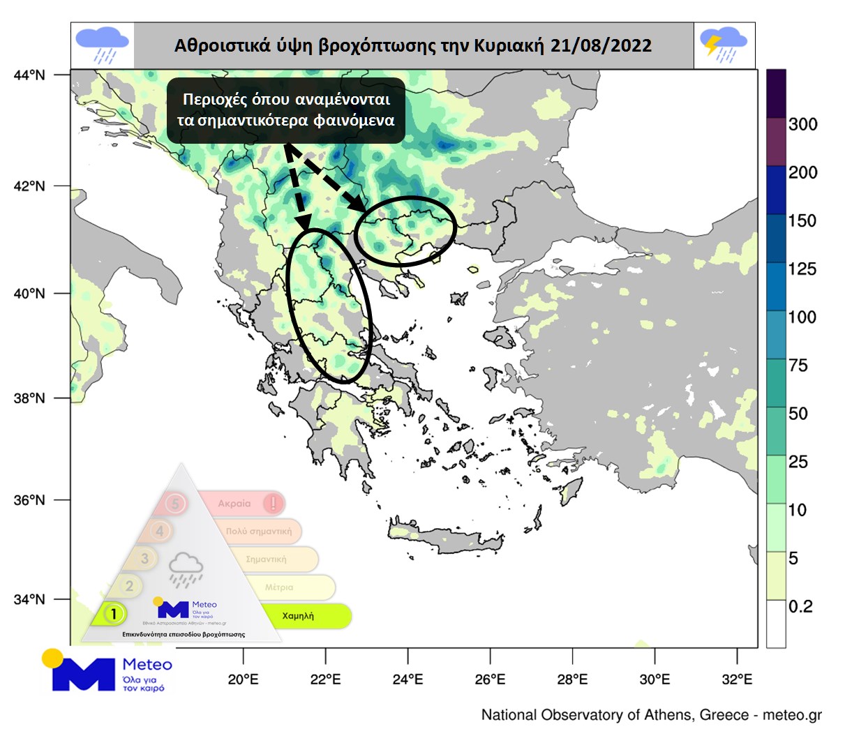
The weather change will start today, mainly affecting Northern Greece, as well as some parts of Central Greece.
It is noted that:
- Strong phenomena will not be of the usual local nature of the summer months, but will be of a generalized nature and, in addition to the mainland, will also affect some island parts of the Ionian and Aegean Seas, as well as Crete.
- The days with the most severe impact are assessed on Tuesday 23 August and Wednesday 24 August.
- The regions that will be affected include the prefecture of Attica and the city of Athens.
Rain, thunderstorms and a noticeable drop in temperature today
Unstable weather with local rains and thunderstorms is predicted in the north of the country today Sunday, according to the National Meteorological Service (NMS), while phenomena are likely to be intense at times in Macedonia.
Light cloud cover is expected in the rest of the country, which will gradually increase in the continental regions, with localized showers and occasional thunderstorms in the central continental regions. In the evening, the apparitions will be limited to central and eastern Macedonia and Thrace.
The wind will blow to the west and north from the northern directions with a force of 3-5 and in the Ionian Sea area with a force of 6 on the Beaufort scale with weakening at night. In the rest from the western directions from 3 to 4 and in the southern part of the Aegean from 5 to 6 points on the Beaufort scale.
The air temperature will noticeably drop across the country and return to normal levels for the season. The maximum values in Macedonia and island Greece are from 28 to 32 degrees, and in their other regions from 32 to 35 degrees Celsius.
Detailed EMR forecast
MACEDONIA, THRACY
- Weather: unstable. Occasional local rains and storms will occur, mainly in Macedonia, where effects may be temporarily severe.
- Winds: northerly from 3 to 4 on the Beaufort scale.
- Temperature: 20 to 31 degrees Celsius and in Thrace up to 33 degrees.
IONIAN ISLANDS, EPIROS, WESTERN MAIN, WESTERN PELOPONNISE
- Weather: A few clouds that will gradually increase in continental areas and there will be occasional storms in the highlands of Epirus during the midday and afternoon hours.
- Winds: NW 4 to 5 and in the Ionian temporarily up to 6 Beaufort locally.
- Temperature: 22 to 34 degrees Celsius.
THESSALIA, EASTERN CONTINENT, EASTERN PELOPONNISE
- Weather: Partly cloudy, which will gradually increase locally, and in the afternoon hours in Thessaly and in the mountainous regions of eastern Sterea and the northeastern Peloponnese there will be local showers and occasional thunderstorms.
- Winds: northerly 3 to 4 points and southwesterly in places 5 points on the Beaufort scale.
- Temperature: 25 to 35 degrees Celsius.
CYCLADES, CRETE
- Weather: generally clear.
- Winds: northerly 3 to 4 Beaufort and in Crete westerly 4 to 6 Beaufort.
- Temperature: 24 to 32 degrees Celsius.
EAST AEGEAN ISLANDS – DODECANIS
- Weather: clear.
- Winds: North-Northwest 3 to 5 Beaufort.
- Temperature: 25 to 33 degrees Celsius.
EUBEA
- Weather: Generally clear, partly cloudy at noon and in the afternoon.
- Wind: North 3 to 4 on the Beaufort scale.
- Temperature: 23 to 34 degrees Celsius.
What is the weather like in Athens and Thessaloniki today?
ATTICA
- Weather: Generally clear, partly cloudy during midday and afternoon hours, so localized showers are likely in the north of the prefecture.
- Winds: 3 to 4 on the Beaufort scale.
- Temperature: 24 to 35 degrees Celsius.
THESSALONIKI
- Weather: unstable. Intermittent local showers and thunderstorms.
- Wind: North 3 to 4 on the Beaufort scale.
- Temperature: 22 to 31 degrees Celsius.
Weather forecast for tomorrow, Monday
Tomorrow, Monday, in Thessaly, Macedonia and gradually in the Sporades and Evia, a temporary increase in cloudiness is expected with local rain or showers, which will intensify during the noon and afternoon hours, and some thunderstorms will occur. During the noon and afternoon hours, the phenomena will spread to the eastern mainland, the highlands of Epirus and the highlands of Crete. By evening, the phenomena will be limited to eastern Macedonia. In the rest of the territory, the weather is generally clear with a little passing cloudiness.
The wind will be west northwest from 3 to 4 points, in the Ionian Sea in some places 5 points on the Beaufort scale and in the morning hours northeast, northeast from 3 to 4 points on the Beaufort scale. The temperature will drop a little more and its maximum value will reach 31-33 degrees Celsius.
Source: Kathimerini
James Springer is a renowned author and opinion writer, known for his bold and thought-provoking articles on a wide range of topics. He currently works as a writer at 247 news reel, where he uses his unique voice and sharp wit to offer fresh perspectives on current events. His articles are widely read and shared and has earned him a reputation as a talented and insightful writer.