
The low atmospheric pressure affecting our country in recent days is expected to strengthen, leading to severe bad weather Today is Thursday.
According to the meteorological service, at first ionian islands and in western continental, which will be locally accompanied by increased electrical activity and hail. The rest of the country will experience local precipitation.
Strong phenomena will gradually move further east and affect whole country. Now the prefecture is included in the “frame”. Attica and her city Athensas well as its prefecture and city Thessaloniki. There will be fewer events in Crete and until late in the evening in Thrace.
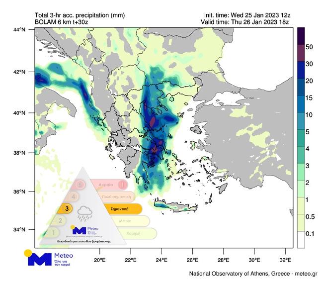
According to the classification of precipitation episodes (RPI) used by the Meteorological Service of the National Observatory of Athens, rainfall episode occupies a place in Category 3 (important). The forecast map below shows the expected distribution of precipitation (rain/snow) over a three-hour period from 17:00 to 20:00 on Thursday.
Nearby, heavy snowfalls will take place in the continental highlands, as well as in the semi-mountainous regions of northwestern, central and northern Greece (indicative heights of over 600 meters and over 300-400 meters in Western Macedonia).
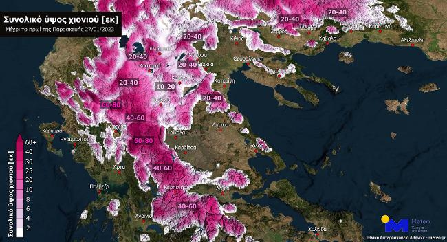
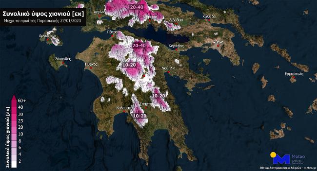
Snow expected in some cities Western Macedonia. Snowfall in some places will continue after the change of day. The forecast maps below show the estimated amount of snow until Friday morning.
Monday Forecast
Details are expected today heavy rains and storms almost throughout the country. Especially in the Ionian Islands and the western part of the mainland, these phenomena will be locally accompanied by increased electrical activity and hail.
Strong phenomena will gradually move further east and affect the entire country. There will be fewer events in Crete and until late in the evening in Thrace.
Dense snow falls will take place in the continental highlands, as well as in the semi-mountainous regions of northwestern, central and northern Greece (indicative heights of more than 600 meters and more than 300-400 meters in Macedonia). Snowfall is expected in the cities of Western Macedonia.
OUR temperature will fluctuate in Western Macedonia from -3 to 3 degrees, in the rest of Northern Greece from -1 to 8, in Epirus from 1 to 11 degrees, in Thessaly from 2 to 10, in Western and Southern Peloponnese from 6 to 14 degrees, on the rest of the mainland from 4 to 12, in the Ionian Islands from 9 to 14 degrees, in the North Aegean islands from 5 to 12 and in the rest of the island parts of the Aegean Sea and in Crete from 9 to 17-18 degrees Celsius.
Northeast winds will blow in the northern part of the Aegean winds with an intensity of 6-7 Beaufort, with a progressive increase locally to 8 Beaufort and in the rest of the SE Aegean to 7-8 Beaufort and possibly temporarily locally to 9 Beaufort.
AT Attica Heavy showers and thunderstorms are expected in places, mostly in the afternoon. The wind will first blow from the northeast with a force of 3-4 on the Beaufort scale, then quickly southeast with a force of up to 6 on the Beaufort scale. The temperature will fluctuate from 7 to 12-13 degrees.
AT Thessaloniki we expect rain and possibly thunderstorms. Temporary snowfalls will occur in mountainous and semi-mountainous regions. The wind will blow from the east with a force of 3-5 on the Beaufort scale and from noon a northerly direction with the same force. The air temperature will fluctuate from 3 to 7 degrees.
Problems in Zakynthos – 112 in half of Greece
It has been raining heavily since yesterday morning Zakynthos. According to local imerazante.gr, two major landslides occurred on the island and roads were closed as a precaution.
From Wednesday afternoon they began to appear flood events in various parts of the island and in particular in Lagan, Kalamaki and Agios Dimitris.

In Imathia, heavy rains caused the pavement to fail, causing part of the Paleo Prodromos-Coulouras bridge to collapse, ERT reports.
The competent authorities decided to activate the system 112 to send warning messages to residents of specific areas depending on the development of phenomena.
Yesterday, warning messages were sent from number 112 to residents of Kefalonia, Ithaca, Lefkada, Zakynthos, Etoloakarnania, Achaia, Elijah, Corinthia, Argolis, Laconia, Messinia, Eastern Arcadia, Karditsa, Trikala and Western Macedonia.
Northern Greece is dressed in “white”.
Snowfall has already been recorded in many areas of northern and mountainous Greece. AT Florina, the local community of Kelly in Amintaio, as well as Pisoderi, dressed in white. The movement of vehicles is carried out with winter tires or chains for the movement of vehicles.
Heavy snowfall in the mountains of the prefecture Yanina, according to ERT. In Metsovo, the snow exceeded 15 cm, and Milia Metsovou, Vovusa, Sirako in Tsumerka and many villages of Zagori are dressed in “white”.
Where are chains needed?
in regional road network Janinas are required in some sections non-slip chains for the movement of vehicles, while drivers traveling both along Egnatia Street and the rest of the road network must be equipped with anti-skid chains or winter tires.
It is noted that the traffic police of Ioannina prohibited truck traffic over 3.5 tons in Kozani. The decision to ban trucks came after a problem in Malacca where a truck folded.
Concerning Western Macedoniaaccording to EL.AS., snow chains or tires are required:
- Sta Grevenaon the Egnatia road, from km 121 (Panagia A/S) to km 150 (Venetika junction), on the national road Grevena – Trikala, from km 5 to km 30, on the Grevena – Samarina Provincial Road, from 5th to 54th th km, on the federal road Grevenon – C / K Vasilitsa, from km 5 to 45 and on the regional road Grevenon – Pervoliou – Avdellas, from km 5 to 45.
- AT Kastoria chains are needed, on the provincial road Kastoria – Ioannina (via Kotili), from km 32 to 46 on the provincial road Kastoria – Florina (via Vitsio), from km 18 to 28 and on Kastoria – Amintaio Provincial road (via Kleisuras), from the 26th to the 35th km.
- AT Florina National Highway – Crystallopigi border station (via Vigla), from km 6 to 28, along the national road Old Florina – Edessa (via Kelly), from km 22 to 35, along the provincial road Aetou – Nympheu, from km 4 to 9th km and on the provincial road Amintaio – Kastoria (via Sklitros), from 17th to 31st km.
Also from 03:22 Thursday (26-01-2023) a temporary ban on the movement of all trucks over 3.5 tons in both traffic flows on Egnatia Odos, from km 121 (A/K Panagias) to km 150. (Venetic Junction) and on the national road Grevena – Trikala, from the 5th to the 30th km.
Schools are closed today in various regions of the country
Today they will remain closed. schools in Kefalonia, Ithaca, Zakynthos, in the municipality of Argos Mykina, in the municipality of Ermionida, in Nafplion, on Symi and in T.K. Rhizomes.
At the same time, schools in the municipality of Florina will open one hour later than usual today and two hours later in the municipality of Prespa.
EMY Emergency Bulletin
- Heavy rain and thunderstorms are forecast:
- before noon in the Ionian Islands, in Epirus, western Sterea and the western part of the Peloponnese
- from the morning hours in the east of the Peloponnese and gradually in central Sterea and Thessaly, weakening from noon
- from noon hours in eastern Sterea (including Attica), Evia and Sporades with weakening in the evening
- from noon in the Cyclades and in central and eastern Macedonia
- from early evening in Thrace and on the islands of the eastern Aegean.
- Snowfall will occur in continental mountainous peninsular areas and locally in areas in the north with relatively lower altitude, thick in places:
- in western Macedonia, central Macedonia and Epirus (with an approximate altitude of 400-500 meters and above)
- in Thessaly (with an approximate height of 500-600 meters and above)
- in the western and central Sterea (at an approximate height of 700-800 meters and above)
- from early evening in eastern Macedonia and Thrace (estimated altitude 400-500 meters and above).
- The south wind in the Aegean Sea will gradually increase to 8 points, and in some places up to 9 points on the Beaufort scale.
- Heavy rains and storms are predicted until the morning in Thrace and the eastern Cyclades and until noon on the eastern islands of the Aegean and the Dodecanese.
- Snowfall will occur in the continental semi-mountainous regions, in some places in Thrace (estimated height of 500-600 meters and above) it will be thick until the morning hours.
- Winds will reach the eastern Aegean in places in the morning from 8 to 9 Beaufort.
Source: Kathimerini
Ashley Bailey is a talented author and journalist known for her writing on trending topics. Currently working at 247 news reel, she brings readers fresh perspectives on current issues. With her well-researched and thought-provoking articles, she captures the zeitgeist and stays ahead of the latest trends. Ashley’s writing is a must-read for anyone interested in staying up-to-date with the latest developments.