
Warm this season weather Christmas this year in Europe and in Greece.
Strange as it may sound, the reason for this is a significant and large-scale meteorological event that has been occurring in the North American region since today Thursday. This phenomenon is expected to have a significant impact on the weather in Europe during the Christmas period.
How cold weather in America brings… heat to Europe
These days North America is being affected by the jet stream, a strong current of air about 10 kilometers above the earth’s surface. This phenomenon contributes to the transfer of very cold gaseous masses of polar origin from the Canadian region to the southernmost latitudes of the United States in the Gulf of Mexico.
At the same time, the specific location of atmospheric systems will contribute to the formation of explosive cyclogenesis (deep barometric minimum) in the Great Lakes region, on the US-Canada border on Friday (December 23).
The formation of this strong barometric low over the North American region is expected to have a significant impact on the more easterly atmospheric circulation over the North Atlantic and Europe in the coming days, according to the latest Meteo forecast data.
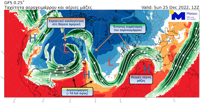
Explosive cyclogenesis over North America is expected to cause significant fluctuations in the jet stream over the North Atlantic and Europe. Strong fluctuations in the jet stream are often associated with extreme and prolonged weather conditions over large areas.
Thus, over the weekend (24-25/12) and at least until the middle of next week, we expect high pressure to prevail over most of mainly southern Europe and a significant increase in temperature over most of Europe, including the US country.
In addition, a significant lack of precipitation is expected mainly in the Mediterranean region, including our country, while more rainy weather is expected mainly in Western/North-West and Central Europe.
Snowfall is expected to occur at high altitudes, mainly in the Alps, and snowfall is likely to occur at low altitudes in the northern parts of the UK.
EMY forecast before Christmas
Usually sunny, mostly cloudy in the south and east. Visibility will be locally limited mainly in the morning and evening hours, mainly in continental areas fog will form.
Winds are variable and weak in the Ionian Sea will blow northwesterly from 3 to 4 points on the Beaufort scale.
The temperature will rise slightly and reach 12-13 degrees in the north, 14-17 degrees in other regions, and 17-18 degrees in the Dodecanese and Crete.
Frosts will be observed in places in the northern continental regions in the morning hours.
Clouds are sparse in places, thicker in others. In the morning and evening hours, visibility will be limited in places, mainly in continental areas, fog will form.
Winds are variable, weak and in the southern seas western northwestern 4-5 points on the Beaufort scale.
The temperature will rise slightly, mostly to the maximum values. In the north it will reach 13-14 degrees, in other regions 16-17 degrees, and in the Dodecanese and Crete 18 degrees Celsius. Frost in places in the morning in the north.
Generally clear weather. Visibility will be locally limited during morning and evening hours, mainly in continental areas where fog is likely to form.
Winds will blow from the north from 3 to 5 points and in the southeastern parts of the Aegean Sea in places 6 points on the Beaufort scale.
Temperatures will rise slightly further and will fluctuate at high levels throughout the season.
Source: Kathimerini
Ashley Bailey is a talented author and journalist known for her writing on trending topics. Currently working at 247 news reel, she brings readers fresh perspectives on current issues. With her well-researched and thought-provoking articles, she captures the zeitgeist and stays ahead of the latest trends. Ashley’s writing is a must-read for anyone interested in staying up-to-date with the latest developments.